![]()

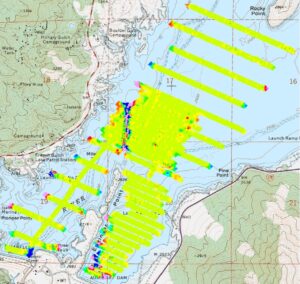
The Marine Magnetometer is the best tool for locating sunken ships, lost anchors, buried pipelines, and other underwater objects containing ferrous metal that disrupt the Earth’s magnetic field. Sea Surveyor uses a GEOMETRICS Model 882 marine magnetometer to precisely measure the Earth’s magnetic field; we then prepare magnetic contour maps that reveal anomalies that represent buried ferrous objects.
The magnetometer sensor is towed 200′ behind the survey vessel to prevent the magnetometer data from being influenced by ferrous metal aboard the boat. To minimize uncertainties in the location of the towed sensor, the survey vessel tows the magnetometer at a slow speed (4-knots) and stays within +5′ of the intended survey line.
Small or deeply buried metal objects are detected by surveying along closely-spaced lines and keeping the towed sensor as close to the seafloor as possible.


![]()

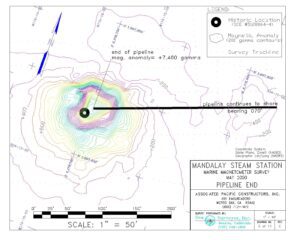
Magnetic signature of pipeline manifold (PLEM) offshore Ventura CA
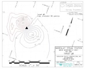
Location of a buried anchor revealed by it's positive/negative anomaly
Magnetic signature of buried concrete canal in Lake Isabella