Client: U.S. Army Corps of Engineers, San Francisco District
Completion Date: 1993
Contract Value: $45K
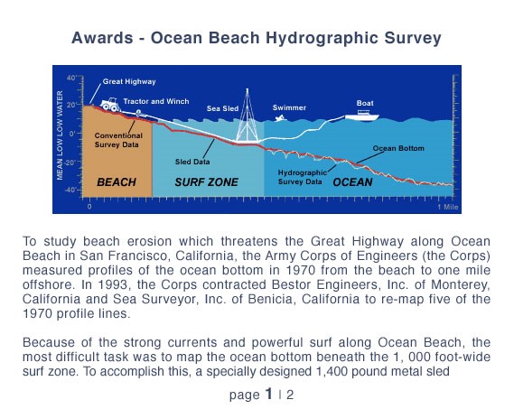
To study beach erosion that threatens the Great Highway along Ocean Beach in San Francisco, California, the Army Corps of Engineers measured profiles of the ocean bottom in 1970 from the beach to one mile offshore. In 1993, the Corps contracted Sea Surveyor, Inc. to re-map five of the 1970 profile lines. Strong currents and powerful surf makes mapping the 1,000 foot-wide surf zone extremely hazardous. Sea Surveyor designed and constructed a 1,400-pound metal sled equipped with a 30-foot long mast with reflector prisms on top. After assembling the sled on the beach, a swimmer tows a rope from a boat to the sled. The boat uses the rope to tow the sled out to the seaward edge of the surf zone. The sled is then slowly pulled back toward the beach by a tractor using a cable and winch, stopping every twenty feet so that a land surveyor can determine the elevation of the seafloor at that location. After each profile line is mapped, the sled is moved down the beach approximately one mile to the next profile line, and the next transect is surveyed. Hydrographic surveying techniques generated the ocean portion of the profile data from the surf zone to one mile offshore. Sea Surveyor’s joint-venture partner, BESTOR ENGINEERS of Monterey, used conventional land surveying techniques to survey the beach portion of the profile mapping.
Sea Surveyor Inc. and Bestor Engineers were awarded the 1994 CELSOC Engineering Excellence Award for successfully completing this hazardous survey of the Ocean Beach Surf Zone.

